


What satellite images reveal about US strikes in Iran
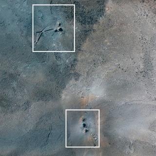
In MapsThree Iranian nuclear facilities were struck by the US overnight between June 21 and 22. Satellite footage analyzed by Le Monde pinpoints the precise impact sites of the bombs and, where visible on the surface, the extent of the damage.
Fourteen ultra-penetrating GBU-57 bombs, each weighing 13 metric tons. According to the United States, these were dropped for the first time in an operational context on two key nuclear sites in Iran on the night of Saturday, June 21. More than 20 Tomahawk cruise missiles were also launched from a US submarine at a third nuclear site in Isfahan.
Were these facilities "fully obliterated," as US President Donald Trump claimed on the night of the attack?

Satellite images and experts interviewed by Le Monde suggest that while there is evidence of these strikes on the surface, it is still difficult to assess the full extent of the damage where the most critical parts of Iran's nuclear program are located: underground.
Fordo

You have 82.83% of this article left to read. The rest is for subscribers only.