


It could be hours, days or weeks away. Or it might not happen at all. On Wednesday, November 15, the Icelandic Meteorological Office (Met) estimated that the probability of an eruption on the Reykjanes peninsula, in the southwest of the country, remained "high".
In the meantime, Iceland is holding its breath and getting ready. The island, situated on the Atlantic ridge between the North American and Eurasian tectonic plates, boasts 33 active volcanic systems – the highest number in Europe – and now, one of its cities is under threat.
A state of emergency was declared on Friday, and the port of Grindavik, some 60 kilometers from the capital Reykjavik was evacuated. Since then, its 3,700 inhabitants – 1% of Iceland's population – have been able to return home, to collect personal belongings. But only if they stayed for a few minutes and were accompanied by security forces.
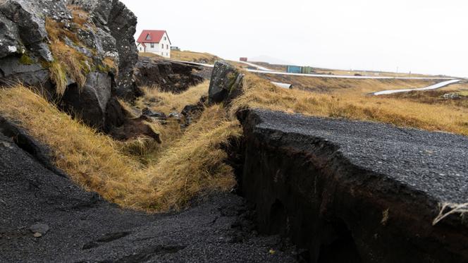
The damage is extensive, as the images of broken roads and cracked buildings show. Not to mention that the situation, "unchanged for four days," according to the Met, could rapidly evolve: "Before an eruption, we should see minor changes in ground deformation and seismic activity, but we shouldn't count on more than half an hour or an hour's notice," estimated geophysicist Freysteinn Sigmundsson.
On the Reykjanes peninsula, lava had not flowed for eight centuries, when it suddenly erupted from a fissure on March 19, 2021, near Fagradalsfjall volcano, attracting thousands of tourists. Since then, two further eruptions have occurred in the vicinity, in August 2022 and July 2023, each time in areas far from any habitation. According to the Met, the fractures caused in the Earth's crust on these occasions could explain the speed with which magma has risen to the surface in recent days.
The earth had already been shaking around Grindavik for several weeks. "We knew that an accumulation of magma had built up, at a depth of around five kilometers, which was causing the tremors," explained Magnus Tumi Gudmundsson, Professor of Geophysics at the University of Iceland. He continued, "On Friday evening, a crack formed in the earth's crust and magma rose vertically at very high speed. If it had reached the surface, we would have had a massive eruption, but it stopped at a depth of around 800 meters."
The fault extends over some fifteen kilometers. "When it was formed, the ground collapsed by about one meter by two meters," Sigmundsson noted. "Now the ground is continuing to drop a few centimeters a day, which means that the crack is widening, which is worrying because it runs through the town of Grindavik," he added. On Wednesday, the Met estimated that the magma was only 500 meters from the earth's surface at certain points along the fissure.
You have 40% of this article left to read. The rest is for subscribers only.