


From villages to dams, a hike along the Dordogne River
FeatureBetween Corrèze, Cantal and Puy-de-Dôme, a 430-kilometer footpath runs more or less alongside the river, offering moments of woodland tranquility and awe-inspiring views of reservoirs steeped in controversy.
"Many of those who had to leave are dead. As a result, we don't talk about it as much." You can hear the sadness in Jean Moussard's voice, the 70-something owner of a large farm housing holiday cottages and guest rooms. In March 1951, after nine years of work, the reservoir lake intended to supply the dam at Bort-les-Orgues (Corrèze) began to fill up.
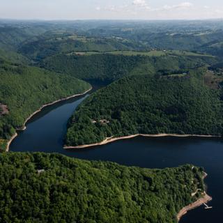
Several villages and houses were swallowed up. Five dams were built in the upper Dordogne valley, sacrificing houses and fields in the name of progress: those at Bort-les-Orgues, Marèges, L'Aigle, Le Chastang and Le Sablier. Today, there are 58 along the entire river and its tributaries. Even if it's only whispered in hushed tones nowadays, many still think that the electricity fairy was too heavy-handed with her magic wand.
Jean-Marc Chirier, a road maintenance worker and first deputy mayor of Gros-Chastang, doesn't deny it. "Despite everything, it's fading. Villages have been rebuilt, and those who knew the old ones are passing away. The dams at L'Aigle and Le Chastang continue to evoke painful memories. But we're not going back." He prefers to see the beauty of these lakes and the new landscape they have created. The forest corridor created as a result, the largest in France, led to the Dordogne being designated a biosphere reserve by UNESCO in 2012.
Chirier decided to turn these controversial dams into a tourist attraction. In 2013, he introduced the idea of a hiking trail linking Confolent-Port-Dieu to Argentat-sur-Dordogne, near the Sablier dam. Spanning the two points are 200 kilometers of trails and 15 days of hiking, more or less along the river. The municipalities involved were immediately enthusiastic. Sixteen of them initially and 19 today are part of the initiative. EDF got involved, providing logistical and financial support.

On the ground, a team of volunteers rolled up their sleeves. They had to mark out existing paths, create new ones, trace the many routes taken by peddlers, cattle merchants, washerwomen and poachers, and obtain permission from landowners to cross their land. Most said yes, despite the potential for future tensions concerning inheritance or onward sales. It was also necessary to find accommodation and campgrounds, and a cab service willing to forward luggage or pick up hikers at the end of the route and take them back to their starting point.
Chirier refused to set up a union, preferring an association framework, named "La Dordogne de villages en barrages" (The Dordogne From Villages to Dams"): "That seemed healthier to me, less open to temptation." A subsidized employment company does most of the work. Maintenance is now carried out by a network of regular volunteers, supplemented by requests on social media when necessary. One of the unresolved difficulties of the route was avoiding the road. In 2015, Itinérêve opened. In 2023, given its success (2,500 hikers a year complete at least one stage), the initiative was extended to the left bank. Today, 430 kilometers of trails are available for those who want to explore them. "I prefer the left bank to the right," said Chirier. "The mountains no longer obscure the view there, and your imagination can run wild."
You have 53.46% of this article left to read. The rest is for subscribers only.