


Flooding in northern France: Satellite images show scale of disaster
NewsCloudy conditions over the northern Pas-de-Calais department of France have limited the number of satellite images that can be captured, but satellite image processing enables us to visualize the extent of the flooding.
Since the beginning of November, the northern French department of Pas-de-Calais has experienced heavy rain, floods and storms. According to Prefect Jacques Billant, the flooding has affected almost 5,000 homes and forced the evacuation of 1,400 people since November 6.
The Sentinel 1 and 2 satellites, placed in orbit as part of the European Union's Copernicus program, monitor the impact of these meteorological events from space. Thanks to the analysis of raw satellite data by a remote sensing algorithm, the Global Flood Monitoring platform regularly records the scale of floods, the cumulative total of which since the beginning of the month is shown in the map below.
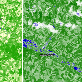
Modified colors to highlight flooded areas
Clouds over the Pas-de-Calais region make it more difficult to get clear images of the floods. "Sentinel 2 sees like human eyes, so it can't give images of the ground when the sky is cloudy," said Annamaria Luongo, a geospatial data consultant who also works for ALSO Space, a Copernicus subcontractor.
These high-resolution optical images are only captured once every five days or so for a given location on Earth, and can only be used if the sky is clear. This is the case for the images of the area around Montreuil-sur-Mer and the commune of Hesdigneul-lès-Boulogne, where water levels have risen several times.
To make the floodwater stand out more clearly, we have artificially colored these images according to the "normalized water difference index." The presence of water, represented in blue, is more visible this way than in raw photographs.


Sentinel 1 is different, as it has the ability to "see through clouds," said Luongo. The satellite provides radar images, the analysis of which "makes it possible to identify ground features," such as the presence of buildings, vegetation and bodies of water.
Another advantage is that "Sentinel 1 has a different acquisition mode [to Sentinel 2], enabling it to provide more images for certain areas of Europe." Thanks to this method, we were able to reconstruct the onset of flooding around Saint-Omer and Calais.


