


Flooding in Northern France: 'It's only logical that rainfall will become more frequent and intense'
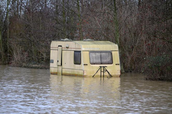
François Gourand, a forecaster at France's weather service Météo-France, spoke with Le Monde about the causes of the heavy rainfall that affected much of northern and western France, as well as the United Kingdom and Germany, causing flooding in all these areas. Already severely affected in November, residents of the Pas-de-Calais region (northern France) have had to flee their homes, particularly near the Aa, a coastal river placed under red alert since Tuesday, January 2.
Since last Sunday, a large part of northern Europe, and particularly the Hauts-de-France region (northern France), has been experiencing heavy rainfall. This is obviously not illogical in winter, but the rain has been very heavy since Sunday. The event occurred in a particular context, with a succession of very humid disturbances. Since autumn, the Pas-de-Calais region has had above-average rainfall. We are in the process of analyzing this, as the episode is not quite over. However, more than 500 millimeters have fallen since mid-October, compared with the normal figure of around 300 millimeters. This has been unprecedented since 1959, when the region's rainfall statistics were first compiled. The previous record was 425 millimeters over the same period in 2000-2001. Nevertheless, the episode is coming to an end. At the end of the week, a high-pressure system will settle over the northern British Isles.
In autumn, a jet stream, a very powerful air current, settled over the North Atlantic. It created particularly massive low-pressure systems that swept along Europe's coasts, such as Storm Ciaran on November 1 and 2. The current was established at the end of an especially warm 2023 [the year in which the global average was the highest since records began, according to Europe's Copernicus program], and after a summer season with striking phenomena in the North Atlantic. There were temperature anomalies both in the atmosphere and on the ocean surface. The situation was conducive to greater evaporation, notably in the tropics. There, the air becomes more humid. When they form, low-pressure systems have much more "precipitable water" at their disposal than in a "normal" year, and when they reach our shores, the effects can be strongly felt.
These are very complex phenomena, and everything has to be taken into account, such as local topography. Even if there are no high altitudes in the area, there can be an elevation effect with hills. Pas-de-Calais found itself in the path of the low-pressure systems that moved up the English Channel. Driven by a westerly or south-westerly wind, they covered a very long distance before hitting the region head-on, as its coastline runs North to South. This year, the temperature in the Channel has remained abnormally high for a very long time, which may have encouraged the low-pressure systems to take on even more moisture at the end of their course.
You have 25% of this article left to read. The rest is for subscribers only.