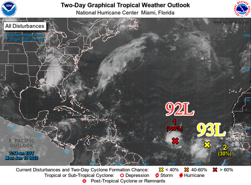


The National Hurricane Center is monitoring two tropical waves that formed off Africa in recent days and are heading west across the Atlantic Ocean. One has a very high probability of formation within the next 48 hours.
Tropical Wave 1, or Invest 92-L, is "midway between Africa and the Lesser Antilles and has become better organized overnight and is close to becoming a tropical cyclone," NHC wrote in a Monday morning update. The weather agency gives 92-L a 100% probability of formation within the next 48 hours.
"It's unusual in June to have a system (Invest #92L) on the verge of developing into a tropical depression or storm, let alone two. 92-L will head in the direction of the Caribbean over the next couple of days, but there are questions," Fox Weather meteorologist Bryan Norcross tweeted.
Computer models forecast 92-L's trajectory is likely the Caribbean Sea, but there are still a lot of uncertainties.
Phil Klotzbach, a hurricane forecaster at Colorado State University, said the early start for deep tropical development between the Caribbean and Cabo Verde off Africa indicates hurricane season could be active this year.
"[E]arly season activity in deep tropics is often a harbinger of a busy season," Klotzbach tweeted.
A big question is if warm Atlantic waters can generate strong enough storms to overcome wind shear produced by El Niño. Wind shear tends to tear apart storms.

