


Major earthquakes have occurred since time immemorial, but their observation and impact have not been evenly distributed around the globe.
On February 6, two earthquakes struck in Türkiye near the Syrian border. Both registered above a 7 on the Richter scale and have a combined death toll rapidly rising past 20,000 people.
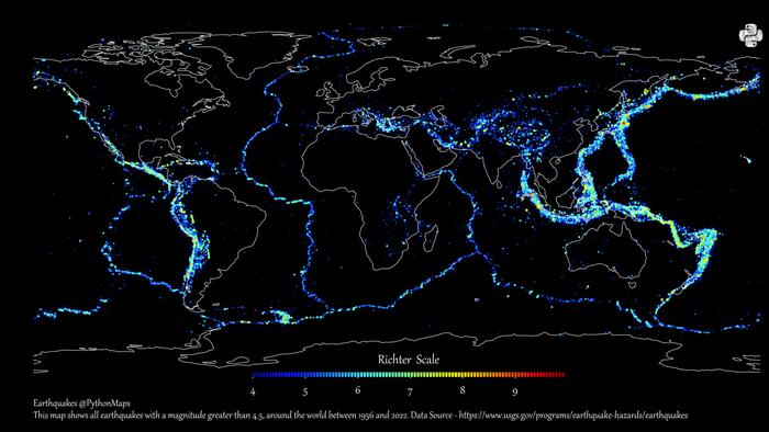
And, as Visual Capitalist's Pallavi Rao details below, looking at the history of recent and ancient earthquakes, the location of these is no surprise. Using data from the United States Geological Survey (USGS), creator PythonMaps mapped earthquake epicenters between 1956 and 2022 that registered a 4.5 or higher on the Richter scale.
Looking at the map, it’s easy to spot the concentration of earthquakes along the boundaries of Earth’s tectonic plates.
These massive moving slabs of rock fit together almost like puzzle pieces, making up the lithosphere or the upper crust. But as the edges of tectonic plates collide, slide against, and move away from each other, the crust cracks and folds and causes earthquakes.
Most of the earthquakes visualized on this map follow the boundaries of the seven major tectonic plates, along with the Philippine Plate (south of Japan) and the Nazca Plate (west of South America).
Here’s a list of the most earthquake-prone areas on the planet, according to the USGS.
According to academics, the recent earthquakes in Türkiye (part of the Alpide Belt) happened on multiple faults. The Arabian Plate likely moved northwards into the Eurasian Plate, pushing the Anatolian Plate (which Türkiye sits on) westward.
Though earthquakes are spread around the world, major earthquakes seem even more tightly confined to specific regions.
These major earthquakes register highly on magnitude scales, such as the Richter scale (ML) and the newer and more commonly-used moment magnitude scale (Mw). These scales are logarithmic and ramp up quickly, so for the Richter scale, each whole number increase roughly corresponds to a 31.6-fold increase in energy released.
The map above sees a concentration of these bigger magnitude earthquakes congregating heavily around both sides of the Pacific Ocean. This border is also known colloquially as the “Ring of Fire” for its persistent volcanic activity, also caused by tectonic plate movement.
But the red points representing major earthquakes registering 9+ on the Richter scale are far and few between. Here’s a list of the 20 worst earthquakes in history, based on magnitude.
Areas near Indonesia, Russia, and Chile - all on tectonic plate boundaries - have seen half of the largest earthquakes recorded in history.
That said, there could have been earlier and larger earthquakes not recorded. Earlier civilizations lacked precise instruments to measure and document them and preserved written observations only, with some of the earliest records dating back nearly three millennia.
Despite the ability to measure both location and intensity of earthquakes (using a seismograph), scientists still cannot precisely predict exactly where, when, or at what magnitude an earthquake will occur.
However, they can measure the probability of an earthquake occurring, especially around fault zones. A famous example is “the big one” around the Cascadia subduction zone in North America which occurs every 200 to 800 years.
In areas that sit on fault lines between plates, earthquake preparedness can play a big role in mitigating risk.