Unfortunately, as the Northwest coastal area of Florida continues to recover from Hurricane Helene, the National Hurricane Center is now warning of a tropical storm in the western gulf, heading East, that is likely to become Hurricane Milton.
There are many variables present within the models for the track of TS Milton as it develops and strengthens into a hurricane. This storm will be a little unique in modern forecast as it is traveling from west to east. Storms that travel this way create a very different set of variables in the cone of uncertainty.
Due to this path, the area north of the impact eyewall will see winds offshore. The area directly south of the impact eyewall will see winds directly onshore. Preparations are always critical within the cone area; however, preparations for a west to east storm are even more critical. A few miles and a little wobble can make all the difference in the storm surge.
Currently the cone of possibility extends from Ten Thousand Islands (South of Naples, FL) all the way to the Big Bend in the Peninsula of Florida. The center is Tampa Bay. The entire west coast of Florida is in the cone of uncertainty.
(NHC) – At 400 PM CDT (2100 UTC), the center of Tropical Storm Milton was located near latitude 22.7 North, longitude 95.5 West. Milton is moving toward the north-northeast near 3 mph (6 km/h). A slow east-northeastward motion is expected to begin tonight. A slightly faster eastward to east-northeastward motion is forecast by Monday and Tuesday.
On the forecast track, Milton is forecast to remain over the southwestern Gulf of Mexico through Sunday night, then move across the south-central Gulf of Mexico on Monday and Tuesday, and approach the west coast of the Florida Peninsula by midweek.
Maximum sustained winds are near 40 mph (65 km/h) with higher gusts. Steady to rapid strengthening is forecast during the next few days. Milton is forecast to become a hurricane Sunday night, and it could become a major hurricane while it moves across the central and eastern Gulf of Mexico. Tropical-storm-force winds extend outward up to 35 miles (55 km) from the center. (more)
The largest variables for Milton are size, intensity and impact zone. Unfortunately, these are significant variables; however, everyone should prepare for the worst scenario and then adjust with additional information as it is provided over the next two days. Do not get complacent with this one.
For those in the cone of uncertainty, remember, planning and proactive measures taken now can significantly reduce stress in the days ahead. Plan when to make the best decision on any evacuation (if needed) consider Tuesday the decision timeframe. As a general rule: take cover from wind – but evacuate away from water.

When the forecast narrows, the area directly SOUTH of the eyewall holds the greatest risk. However, stay calm. You are in control right now. You can make preparations right now. Currently, the centerline is Tampa Bay/St Pete.
The coastal area directly below Tampa/St Pete (Sarasota, Venice, Port Charlotte, Punta Gorda, Cape Coral, Matlacha, Pine Island, Bokeelia, Sanibel Island, Captiva Island, Fort Myers, Fort Myers Beach, Bonita Springs, Naples, Marco Island, and Ten-Thousand-Islands) should be on high alert and paying very close attention.
Again, the difference between Milton being above or below your location will make a lot of difference.
If Milton, traveling West to East, hits below you the hurricane force winds will initially be blowing offshore, pulling water out (tidal variables notwithstanding). If Milton hits above you, the hurricane force winds will initially be blowing onshore, pushing water in. When considering threat variables, the specifics of intensity and eyewall size will play a big role in determining impact scope, storm surge and subsequent damage.
It is very important to pay attention to your local officials and emergency management teams. Each area is very different, and each community can feel a totally different impact depending on topographical, geographical and regional distinctions. Listen to state officials, pay attention to the National Hurricane experts, but the best suggestion is to focus your attention on the advice of local EMS officials.
♦ I am repeating prior advice along with a note about the BUZZSAW part that always gets the most attention.
During a hurricane, even if you experience significant impacts, the odds of being in the eyewall part of the hurricane itself is very low. The eyewall gets all of the attention: windspeed, intensity, Cat status, etc. However, the eyewall is not the total of a hurricane, the eyewall is a very limited area and the most dangerous.
During Hurricane Ian the old axiom remained mostly true, “hunker down from wind, but run from water.”
Now, I say “mostly true“, because to be brutally honest -due to the unique nature of Ian- if you are going to be inside that buzzsaw area (the eyewall) for 8 hours, hunkering down is really not a safe option. Fortunately, Ian was a rare system in terms of its slow-moving nature, even after hitting land. Most hurricane impact events are less than 3 hours in duration. Ian, eight to nine hours, was dangerously unique.
To give scale to the size of the buzzsaw, again we are talking about the most dangerous part of any hurricane – the eyewall itself, this next image shows a comparison between the eyewall of Hurricane Charley in 2004 and the eyewall of Hurricane Ian in 2022.

That is the eye of Charley overlaid inside the eye of Ian in almost the same location. You can see how much bigger the buzzsaw was for Ian as opposed to Charley.
Both Hurricane Charley (’04) and Hurricane Ian (’22) came ashore in generally the same place. Charley made official landfall at Upper Captiva Island and Ian at Bokeelia. The distance between both landfall locations is only about 4 miles as the crow flies.
Both storms were Cat-4 landfall events. However, Charley was much smaller, had a smaller buzzsaw and moved very quickly around 20 mph. Ian was big, had a much bigger buzzsaw and moved very slowly around 5mph.
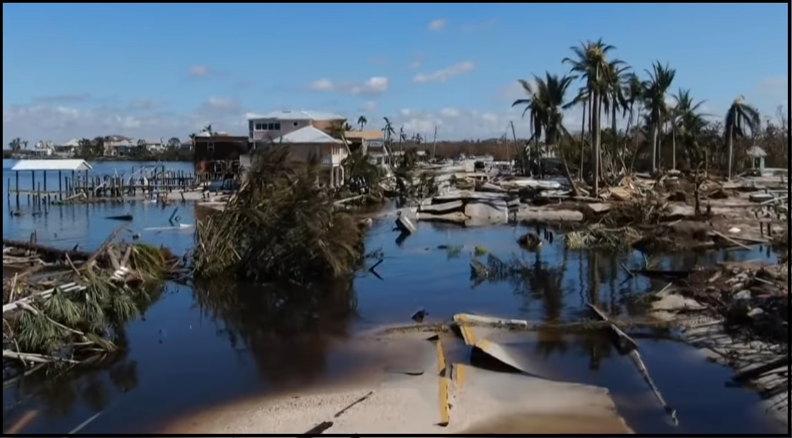
The duration of Charley was around 2 to 3 hrs. The duration of Ian was around 8 to 9 hrs. Ian was bigger and just moved slower. Inside this distinction you discover why, despite their almost identical regional proximity, the damage from Ian was much more severe. Topography was changed.
If there is a possibility you will be hit by the eyewall section; you should evacuate – period!

DAY ONE (Sunday)
Determine Your Risk
Make a Written Plan
Develop and Evacuation Plan
Inventory hurricane/storm supplies.
DAY TWO (Monday)
Get Storm Update
Assemble and Purchase Hurricane Supplies
Contact Insurance Company – Updates
Secure Important Papers.
Strengthen and Secure Your Home
Make Evacuation Decision for your Family.
DAY THREE (Tuesday)
Get Storm Update
Re-Evaluate your Supplies based on storm update
Finish last minute preparation
Assist Your Neighbors
If Needed – Evacuate Your Family
Communication is important. Update your contact list. Stay in touch with family and friends, let them know your plans. Select a single point of contact for communication from you that all others can then contact for updates if needed. Today/tomorrow are good days to organize your important papers, insurance forms, personal papers and place them in one ‘ready-to-go’ location.
You can see the importance of this communication plan, from the recent results of the emergency in Western North Carolina. Tell your family who your primary contact person is, then tell that contact person what you EXACTLY plan to do. That contact person then becomes the information hub for you that relays information to your family and friends.
Evaluate your personal hurricane and storm supplies; update and replace anything you might have used. Assess, modify and/or update any possible evacuation plans based on your location, and/or any changes to your family status.
Check your shutters and window coverings; test your generator; re-organize and familiarize yourself with all of your supplies and hardware. Check batteries in portable tools; locate tools you might need; walk your property to consider what you may need to do based on the storm’s path. All decisions are yours. You are in control.
Consider travel plans based on roads and traffic density. Being proactive now helps to keep any future stress level low. You are in control. If you have pets, additional plans may be needed.
One possible proactive measure is to make a list of hotels further inland that you would consider evacuating to. Make that list today and follow updates of the storms’ progress.
Depending on information tomorrow (Sun/Mon) you might call in advance and make a reservation; you can always cancel if not needed. It is better to have a secondary evacuation place established in advance. Being proactive reduces stress. Even if you wait until much later to cancel, it is better to pay a cancellation fee (usually one night charge) than to not have a plan on where to go. Trust me, it’s worth it. Protect your family. Make the list of possibilities today, make the booking decision in the next 24 to 36 hours.
Look over the National Hurricane Center resources for planning assistance. [SEE HERE]
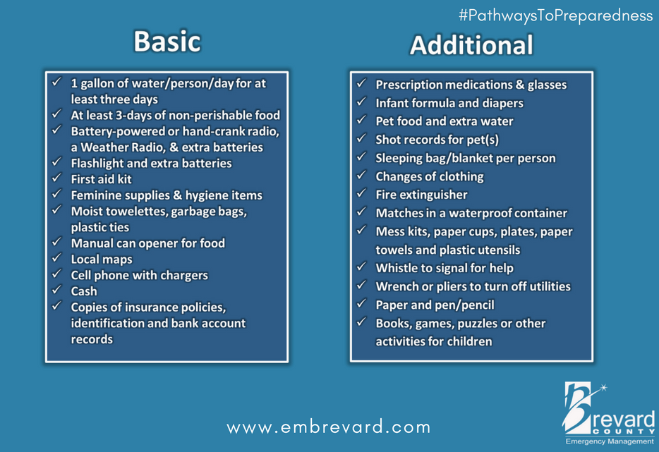
The ‘context’ of Ian in 2022 was shared previously {Go Deep}. What follows below are things to consider if you are prepping for a hurricane impact and/or deciding whether to stay in your home or evacuate. Standard hurricane preparations should always be followed. You need at least three days of food, water and supplies. Protect your family, secure your property and belongings, and prepare for the aftermath.
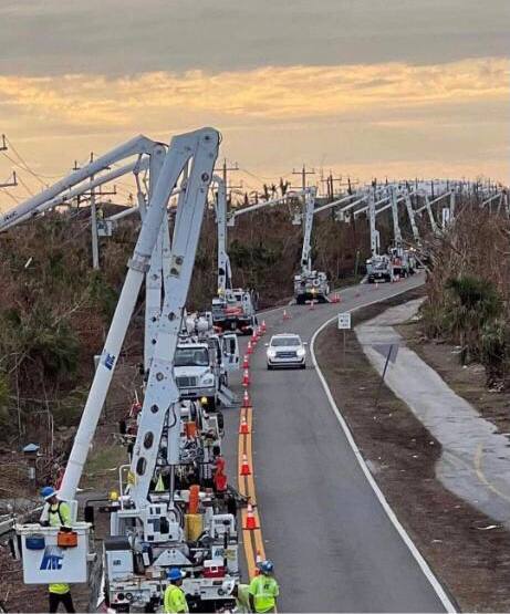 What you do before the hurricane hits is going to determine where you are in the recovery phase.
Additionally, and this should be emphasized and discussed within your family, if you cannot be self-sufficient in the aftermath – for any reason, then you should evacuate.
Self-sufficiency in this context requires being able to cope for up to several weeks:
(1) potentially without power; (2) potentially without potable running water (3) potentially without internet service; (4) potentially without communication outside the region; and (5) with limited municipal and private sector assistance. If you decide you cannot deal with these outcomes, you should evacuate.
Additionally, as a family or individual, you should also honestly evaluate:
(1) your physical abilities; (2) your emotional and psychological ability to withstand extreme pressures; and (3) your comfort in losing daily routines, familiar schedules and often overlooked things you might take for granted.
Post hurricane recovery is fraught with stress, frustration and unforeseeable challenges.
I saw a video presented by a structural engineer who was sharing his experience with Hurricane Ian. I am going to use his video for a few references because even with professional credentials, some of the common mistakes people make are highlighted in his experience. Keep in mind his video is taken about 30 miles inland from where the majority impact area (coastal region) is located.
The video below was shot from the soft side (western side) of the storm, and if we were to scale the difference between his experience and a person who was located in/around Fort Myers Beach, Sanibel, Pine Island or Cape Coral, he would be around a “5” on a ten-point impact scale.
Meaning the severity of conditions 30 miles southeast of him was twice as severe as his inland experience.
Key Points – At the 21: 35 moment (prompted), notice how his #2 vehicle is parked outside. Also, at the 22:00 minute moment, notice what he is describing and showing with his garage door and how his #1 vehicle (a pickup truck) is positioned inside the garage. WATCH:
.
♦ This is exactly what I was talking about in hurricane preparation when discussing the garage door. If that videographer was located 30 miles southeast, and/or his house was positioned facing West, instead of North, his garage door would have failed. If you lose the garage door, YOU COULD LOSE YOUR ROOF.
You can always tell those people who have been through direct hurricane impacts by how they parked their cars. I now include this information in all hurricane prep because it makes such a difference. If you lose your Florida garage door you will more than likely lose your roof. That’s just the reality of having a massive opening in your structure to 100 – 150 mph winds that will lift the trusses.
If you have two vehicles, put one vehicle inside the garage with the front bumper against the door to help stop the flex (do this carefully). Put the other vehicle outside blocking the garage door facing down the driveway or facing parallel to the garage. The goal is to use the aero dynamics of the car to push the wind away from the door and provide protection.
Purchase a cheap car cover to protect the outside vehicle and/or use old blankets (cable ties, bungee cords) to stop the outside vehicle from getting sandblasted and destroyed. Place double folded corrugated cardboard in front of the radiator to protect it from storm debris.
Additionally, if you live in a flood zone, or if you are concerned about storm surge, the day before impact take your #1 car to the nearest airport or hotel with a parking garage and park in the upper levels. Take an uber back home if you don’t have a friend or partner to help you. This way you know you will have one workable vehicle, just in case.
♦ Another lesson from Ian, if you drive an electric vehicle and sustain saltwater intrusion (of any level) your car is not safe. Saltwater makes the vehicle batteries extremely dangerous, and they could spark or catch fire. Multiple homes survived Hurricane Ian only to have the electric car catch fire in the garage and burn the house to the ground. Hurricane rain is wind-driven Gulf saltwater. The fire department was begging people to put their EVs outside and not to plug them in. Dozens of EVS also erupted in flames while driving down the streets after the storm.
♦ Notice at 24:30 of the video this professional structural engineer is standing and physically supporting his glass patio doors, with his wife, trying to keep them from breaking in due to wind and pressure changes. DO NOT DO THIS ! That is beyond dangerous. Any small item of debris (even a small twig or branch) could hit that window and shatter it, turning flying glass into instant flying blades.
Instead, put 3/4-inch plywood or steel bolted hurricane shutters over all your windows and doors. Period. This is not an option. My steel bolted hurricane shutters were hit with debris so hard – whatever it was, physically dented the steel. Every window and door need to be covered and protected, especially glass patio doors (even if tempered). Do not think you can stand there and protect glass doors. It’s beyond dangerous.
♦ Hardening your home is a matter of careful thought and physical work. However, every opening into your structure must be protected, leaving yourself with one small exit opportunity just in case. Hopefully you have a bolted door with no glass windows you can use as an emergency exit. If not, select a small window and leave only enough room uncovered for you to get out in case of emergency or structural collapse.
Beyond the ordinary supplies like drinking water, batteries, flashlights, battery or hand-crank radio, generators, gasoline, etc. Evaluate the scale of what you have against the likelihood of weeks without power or water. A few pro tips below:
♦ Put three 30-gallon trash cans in the shower and fill them with water before the storm. This will give you 90 gallons of water for cooking and personal hygiene. You will also need water to manually flush your toilets. Bottled water is great for drinking, hydrating and toothbrushing, but you will need much more potable water if the municipal supply is compromised or broken.
♦ A standard 6,500-to-8,500-watt generator will run for approximately 8 hours on five gallons of gasoline. Do not run it all the time. Turn it on, chill the fridge, make coffee, use the microwave or charge stuff, then turn it off. Do this in 4-hour shifts and the fridge will be ok and your gasoline will last longer. Gasoline is a scarce and rare commodity in the aftermath of a hurricane. Gas stations don’t work without power. Check the oil in the generator every few days. Also, have a can of quick start or butane available in case the generator starts acting up.
♦ Extension cords. If you are purchasing them buy at least one 100 to 150′ extension cord with a triple ponytail. This way you can use one cord into a central location to charge up your electronic devices. Establish a central recharging station for phones, pads, laptops, and rechargeable stuff.
♦ Purchase a box of “contractor garbage bags” and just keep them in the garage. These are large, thick, industrial trash bags that fit 40-gallon drums. They can be used for trash, or even cut open for tarps in the aftermath of a storm. These thick mil contractor bags have multiple uses following a hurricane.
♦ Do all of your laundry before the hurricane hits. You will likely not have the ability again for a few weeks.
♦ Cook a week’s worth of meals in advance of the hurricane. Store in fridge so you can microwave for a meal. Eating a constant diet of sandwiches gets old after the first week. Dinty Moore canned beef stew and or Chef-boy-ardee raviolis can make a nice break…. anything, except another sandwich.
♦ Have bleach for use in disinfecting stuff before and after a hurricane. Also have antibiotics and antiseptics for use. Hygiene and not getting simple infections after a hurricane is critical and often forgotten. Again, this is where the extra potable water becomes important. Simple cuts and scrapes become big deals when clean potable water is not regularly available. Keep your scrapes and abrasions clean and use antiseptic creams immediately.
♦ Do not forget sunscreen and treatments to relieve muscle aches and pains. Hurricane recovery involves physical effort. You will be sore and/or exposed to the elements. Remember, it’s all about self-sufficiency because the normal services are not available. A well-equipped first aid kit is a must have.
♦ Buy a small camping stove. Nothing big or expensive, just something you can cook on outside in case of emergency. It will be a luxury when you are 2+ weeks without power and all the stores and restaurants are closed for miles.
 ♦ Those small flashlights that you can strap around your head that take a few AAA batteries? Yup, GOLD. Those types of handsfree flashlights are lifesavers inside and outside when you need to see your way around. Nighttime is especially dark without electricity in the entire town. Doing stuff like filling a generator with gasoline in the middle of the night is much easier with one of those head strap flashlights. Strongly advise getting a few, they’re inexpensive too.
♦ Cash. You will need it. Without power anything you may need to purchase will require cash, especially gasoline. Additionally, anyone you hire to help or support your immediate efforts will need to be paid. Cash is critical. How much, depends on your individual situation, but your cash burn rate could go into the thousands in the first few days. Also keep in mind, you may or may not be able to work and without internet access even getting funds into place could be challenging.
♦ Hardware. A box of self-tapping sheet metal screws (short and long) is important, along with a box or two of various wood screws or Tyvex screws. A battery drill or screw gun is another necessity. Check all of this stuff during hurricane prep.
Depending on proximity, this can be a fury of nature; a battle where the odds are against you, that you may or may not be aware you are contemplating when you are choosing to stay or evacuate. It’s not the hurricane per se’, it’s that much smaller killer buzzsaw – the eyewall- that you are rolling the dice, never to see.
When it comes to the eyewall, the truest measure of the “cone of uncertainty“, the difference between scared out of your mind and almost certain death, is literally a matter of a few miles; and there ain’t no changing your mind once it starts.
If you have doubts, fears or worries, trust your instincts. Lockdown, clean up outside, bring inside all the patio furniture or throw it into the pool, and just evacuate.