


The National Hurricane Center is narrowing the forecast path of Hurricane Helene, while strongly emphasizing the importance of preparation for a dangerous storm impact in the Florida panhandle region. Everyone in the area should pay close attention.
Helene is anticipated to intensify tomorrow and start moving forward very quickly. This can push the wind driven water very severely into the upper Florida coastal area. The storm surge is anticipated to be very dangerous. Evacuations are beginning and all preparation should be rushed to completion. [NHC Center Here]
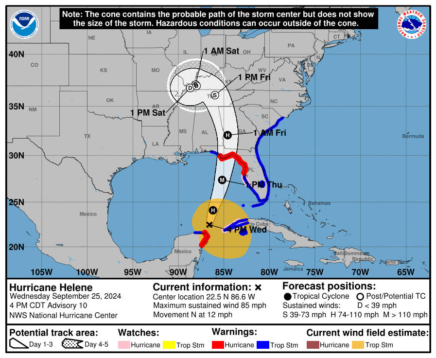
At 400 PM CDT (2100 UTC), the center of Hurricane Helene was located near latitude 22.5 North, longitude 86.6 West. Helene is moving toward the north near 12 mph (19 km/h). A northward or north-northeastward motion at a faster forward speed is expected during the next 36 hours. On the forecast track, Helene will move across the eastern Gulf of Mexico tonight and Thursday and cross the Florida Big Bend coast Thursday evening. After landfall, Helene is expected to turn northwestward and slow down over the Tennessee Valley on Friday and Saturday.
Maximum sustained winds are near 85 mph (140 km/h) with higher gusts. Strengthening is forecast, and Helene is expected to be a major hurricane when it reaches the Florida Big Bend coast Thursday evening. Weakening is expected after landfall, but Helene’s fast forward speed will allow strong, damaging winds, especially in gusts, to penetrate well inland across the southeastern United States, including over the higher terrain of the southern Appalachians. (read more)
Fortunately, the eyewall -the area of strongest winds- is likely to be tight and small; however, the outflow wind field is likely to be very large which makes the water pushing into the coastal region more concerning.
.
Those in the impact zone should leave if possible. No-one should remain on/near the coast. A category-4 storm can and will damage structures, buildings and landscape.
This storm is very similar to Hurricane Charley which impacted the SW coast of Florida in 2005. The coastal topography can change in the 30 mile-wide area of immediate impact.
Infrastructure failure should be anticipated, and it could take weeks for restoration. The coastal communities are the most vulnerable; however, the inland impact of the storm will continue unimpeded until the eyewall crosses onto land.
That means communities inland for 50 miles will likely see consistent 100+ MPH winds for several hours. That scale of sustained wind energy will snap power poles and weaken reinforced concrete.
As the backside of the storm then reverses the energy direction, any already compromised structures will not withstand the additional pressure. In many cases the backside of the storm is worse than the front.
If you are at/near the coast, in the zone of eyewall uncertainty, the time to get out is tomorrow. Don’t wait. Take all mandatory evacuations seriously. If you are inland, prepare yourself for a long duration of extensive wind damage followed by an extended power outage.
Do not panic or stress with dark imaginings. However, all hurricane preparation should be rushed to completion.

Due to the speed of this storm, and the rapid intensification strength, all interests in the coastal area should immediate rush to completion their hurricane and storm preparation plans. Thursday is likely the last day to prepare your property and personal effects. Do not delay. Pay attention to the warnings and guidance of local officials.
If you live in an evacuation zone, be prepared to respond as soon as instructed. Take this storm seriously. Slight variations in the storm’s path can create major changes within any impacted region.