


An amber heat health alert has been issued for five major regions in Britain as temperatures are set to soar to at least 35C, according to weather maps.
Issued jointly by the Met Office and the UK Health Security Agency (UKHSA) the heat alerts have been issued from 12PM on June 27 to 6PM on July.
Warnings for hot weather will be in effect for the East Midlands, East of England, London, South East, and South West.
While the alert is in force, health and social care services are likely to face significant impacts, which could result in a rise in deaths, particularly among those aged 65 and over or with health conditions.
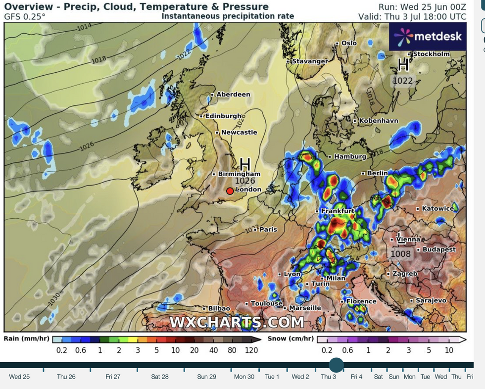
The high heat will result in Britain being on drought alert with a ‘Mediterranean summer’ threatening weeks of rainless skies.
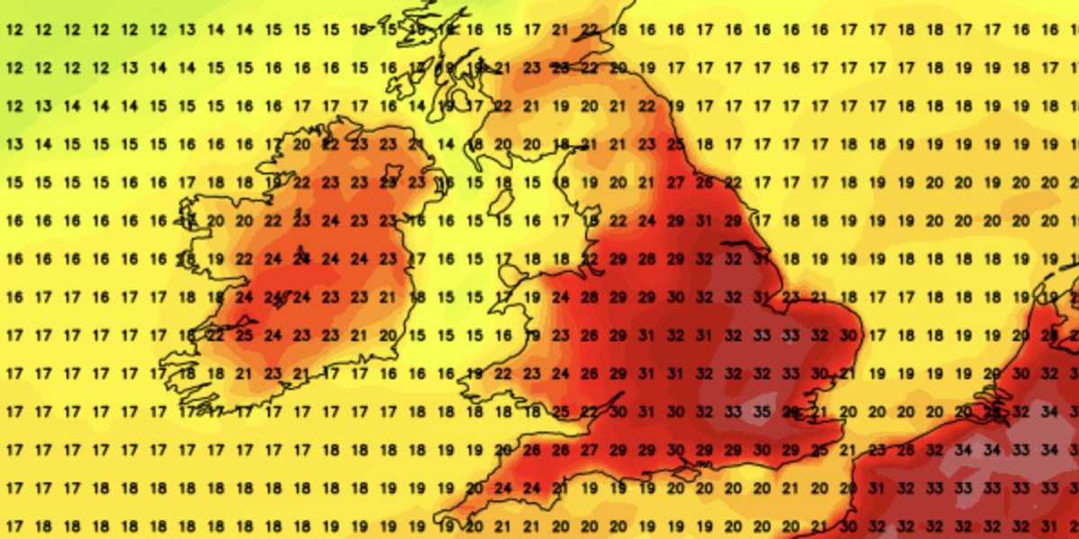
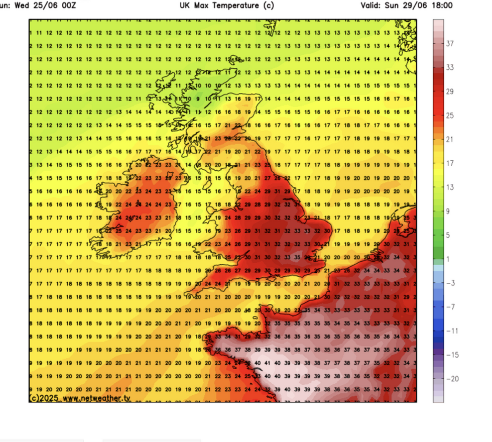
Temperatures this weekend are poised to soar back into the 30Cs as high pressure builds across the UK.
The outlook through the start of July is for persistent dry skies, sparking fears of a desert summer.
Jim Dale, meteorologist for British Weather Services, said: “The southeast is looking like the Mediterranean, it is similar to what you would expect in Spain, and with more hot weather on the way, it is going to be unusually dry.
“This is where we start to worry about drought, because after the very dry spring, there is no sign of any significant rain on the way.
Temperatures up again this weekend
NETWEATHER
“We have had next to zero rainfall since winter, and there is nothing in the forecast, so although we are going to probably be talking again about heatwaves, the greatest risk is from drought and everything that comes with that.”
After a brief respite from last week’s heatwave, thermometers will this weekend head upwards.
Weather models show temperatures in the south and the southeast back in the 30Cs.
A cold front passing across Britain over the next couple of days will bring outbreaks of rain and fresher winds to the north.
High pressure building across southern England will push the mercury upwards, although the heat will be less intense than last week.
Met Office meteorologist Aidan McGivern said: “By the time we get to Sunday, the jet stream is beginning to push north again, and higher pressure is beginning to move up north again.
“Some of that heat over the Continent can start to drift north, and so it is going to be more localised and less intense than the last hot spell, but there is the potential for some reasonably high temperatures in the south and the southeast.
“On Monday, widely across many parts of England and Wales, we can expect temperatures to be in the low- to mid-20Cs, and across southeastern areas into the high-20Cs and perhaps the potential for 30C.”
A dry summer would follow the warmest spring on record and also the driest with rainfall around 40 per cent below average.
A mean temperature of 9.5C broke the record by 1.4C with all four nations coming in hotter than average.
The Met Office’s three-month summer outlook predicts a 45-per-cent chance of a hotter-than-average summer.
It warns further heatwaves are possible before autumn, with climatic factors to blame including a ‘global warming trend’.
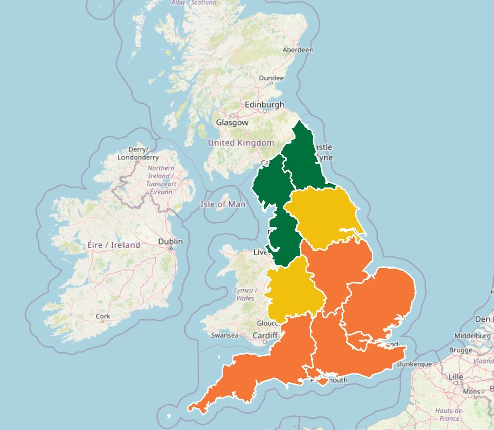
The Met Office and UKHSA issued a joint amber heat health alert for East Midlands, East of England, London, South East, South West
UKHSA/MET OFFICE
A spokesman said: “There is an increase in the likelihood of hot conditions which is consistent with our warming climate.
“This doesn’t necessarily mean the UK will see heatwaves and heat-related impacts but the risk of these is higher than normal during this period.
“There is a very slight preference for high pressure close to and across the UK, but this signal is rather weak.”
Much of southern Britain will turn drier and warmer this weekend, according to AccuWeather’s lead international forecaster Jason Nicholls.
He said: “There may be showers in the north on Friday and into the weekend, but the south should stay drier and brighter.”