


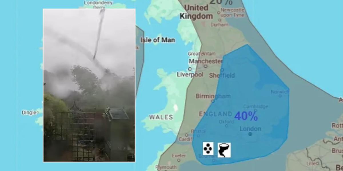
A moderate tornado has been described as “scary” as it swept through Pulborough in West Sussex, felling trees in its path.
Despite significant environmental damage, no homes were reported damaged in the weather event on Saturday afternoon.
The Tornado and Storm Research Organisation (Torro) said that English southern coastal counties from Devon through to Kent experienced unusually strong winds between 2pm and around 7.30pm on June 7.
The organisation’s investigator posted on social media that they had given the tornado a preliminary T2 rating, which would rate it as a moderate tornado.
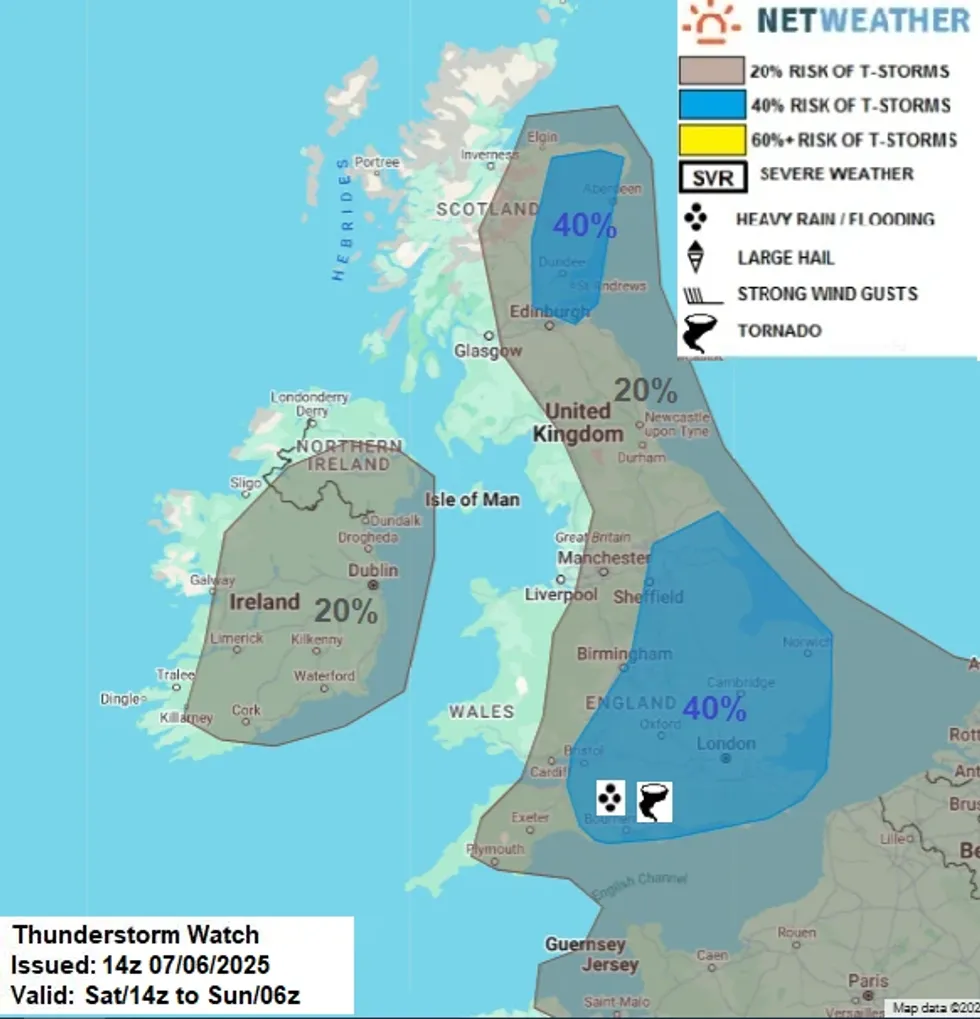 Netweather map shows localised risk of tornadoesNetweather
One social media user wrote: "Opposite where I live, it was over quite quickly, but quite scary to see."
The tornado hit following a weather warning last Friday which warned that the UK could be hit by flash floods and, in places, could be threatened by freak tornadoes.
Netweather forecaster Nick Finnis, warned of "heavy showers and thunderstorms" particularly across central, southern and eastern England.
This forecast was echoed by the Met Office, which issued a yellow thunderstorm warning this morning for East Midlands, East of England, London, South East and South West.
The alert stretched for a full 12 hours from 9am to 9pm on Saturday and warned "heavy showers and thunderstorms may lead to some disruption to transport and infrastructure".
Issuing further details about the yellow warning, the Met Office wrote: "Frequent heavy showers and thunderstorms are expected for much of Saturday before fading from the west during the mid to late afternoon.
"10-15 mm of rain could fall in less than an hour, whilst some places could see 30-40 mm of rain over several hours from successive showers and thunderstorms.
"Frequent lightning, hail and strong, gusty winds will be additional hazards."
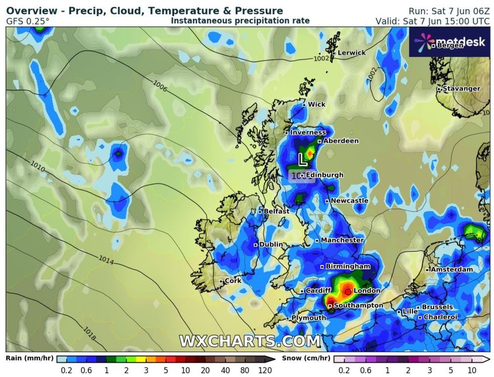 WX Charts map shows heavy rain to strike across UKWX Charts
Writing for Netweather, Finnis said: "Dry air entrainment aloft from the jet stream may enhance instability and bring strong winds aloft towards the surface as isolated strong gusts.
"With steep lapse rates and dry air entrainment, isolated large hail is possible too, while convergence and local backing of winds against the strong westerly flow aloft may enhance low-level shear enough to allow rotating updrafts and an isolated tornado risk.
"Localised intense rainfall may also lead to flash-flooding where storms train along convergence zones."
However, in an update at 2pm on Saturday, Finnis added: "More organised rain than expected along a back-bent occlusion moving in across southwest England and moving east across south England has meant cloud cover has limited surface heating, thus convective initiation has struggled so far this afternoon."