Storm surges expected along Southeastern coast through the night, NWS says
Storm surges are expected to impact much of the Southeast coast through tonight as Idalia continues its path sustaining tropical storm-force winds of up to 60 mph, according to an 11 p.m. ET update from the National Weather Service (NWS).
Coastal flooding is also expected in Storm Surge Watch areas in North Carolina on Thursday, NWS noted its latest update.
Idalia is currently 15 miles northwest of Charleston, South Carolina. Here's where you can track the storm's path.
7 min ago
Here's the latest on Idalia's path
From CNN staff
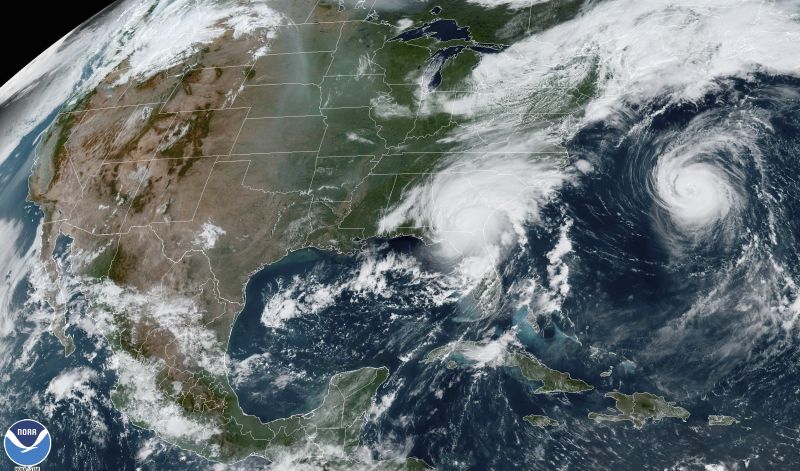
This satellite image from 11:21 a.m. ET shows Hurricane Idalia, center, over Florida and crossing into Georgia, and Hurricane Franklin, right, as it moves along off the East coast of the United States on August 30, 2023. NOAA/AP
Idalia touched down on Florida's Gulf Coast early Wednesday as a Category 3 hurricane, making it the strongest to make landfall in the Big Bend region in more than 125 years.
Idalia weakened to a tropical storm Wednesday night and continues to weaken as it treks across the Southeast, according to the National Hurricane Center.
The center of the storm is now moving through South Carolina and is 60 miles west of Charleston, the center said. In addition to the surge, heavy rain, gusty winds and the threat for tornadoes will continue into the overnight hours for eastern sections of the Carolinas.
Here's what else you should know:
Georgia: Flash flood warnings were issued across parts of Georgia as the state braced for Idalia. All flights out of Savannah/Hilton Head International Airport were canceled for the rest of Wednesday, the airport posted on social media. And government offices for the city of Savannah will remain closed Thursday due to the weather, the city announced in a news release Wednesday.
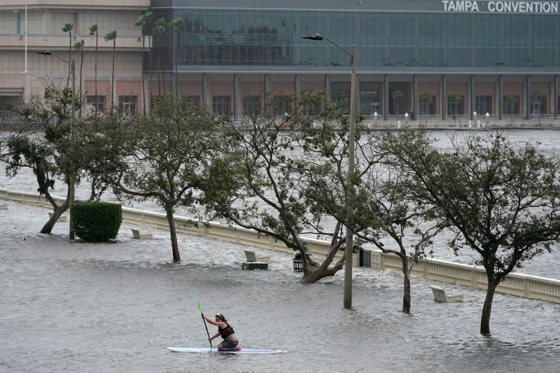
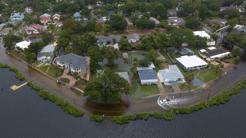
Florida: About 150 residents were rescued from flooded neighborhoods in Pasco County as Hurricane Idalia moved through Florida, according to an official. Some areas of Florida saw more than 9 inches of rain and winds up to 85 mph, according to preliminary reports. A 15-mile stretch of Interstate 10 in Madison County remains closed, although the department of transportation is working to have it re-opened tonight, Florida Gov. Ron DeSantis said Wednesday. About 4,000 to 6,000 homes were damaged in Florida's Pasco County during the storm, according to Pasco County Administrator Mike Carballa. Florida’s biggest concern following Hurricane Idalia is people who do not have power, according to Kevin Guthrie, the state's director of emergency management. Also, there have been reports of people looting in the aftermath of Hurricane Idalia in Steinhatchee, a village in hard-hit Taylor County, DeSantis said Wednesday.
The Carolinas: North Carolina Gov. Roy Cooper urged residents to stock up on supplies and stay off flooded roads when Hurricane Idalia hits the area with heavy rainfall and localized flooding. A state of emergency was declared Monday for the state and a tropical storm warning is in effect for the entire coast of the state, Cooper said. Some schools in North Carolina are closing early or canceling activities as Hurricane Idalia moves toward the state. South Carolina Gov. Henry McMaster said he doesn’t think the storm will be as bad as previous hurricanes that have hit the state.
Power outages: More than 460,000 customers are without power in Florida and Georgia on Wednesday evening, according to tracker PowerOutage.Us.
Charleston Harbor records 5th highest water level ever amid rising storm surge
From CNN's Taylor Ward
The water level in Charleston Harbor has exceeded the forecast of 8.7 feet and is now at 9.03 feet, the National Weather Service posted on X, formerly known as Twitter.
This is the fifth-highest level ever recorded and is only slightly behind values recorded in 2016 with Hurricane Matthew (9.29 feet) and 2017 with Hurricane Irma (9.92 feet). The highest level was 12.52 feet in 1989 during Hurricane Hugo.
High tide was at 8:24 p.m. ET.
7 min ago
Inside a hurricane hunter flight during the storm
From CNN's Victoria Kennedy
The WC-130J Hercules aircraft from the 53rd Weather Reconnaissance Squadron departed Keesler Air Force Base in Biloxi, Mississippi, Tuesday at 11 p.m. ET.
The one time my soul left my body, I was on the flight deck with the pilots. It was dark for the majority of our flight. The lightning was so intense, and the hail hitting the plane was so intense.
“We’re about to go through the eye wall,” a crew member said.
I’m sitting up there with the pilots. We’re rocking and swaying, and all of a sudden, the flight controls start screaming, “Check Altitude. Check Altitude. Check Altitude. Throttle up. Throttle up.” And I’m like, ‘Oh my god, this is what happens in the movies.’
And those pilots were just cool, calm and collected, and steered us through it. It was amazing. We had one moment where we dropped really rapidly because we hit a pocket and everybody on the plane literally levitated. We were kind of airborne.
We went from Category 2 to Category 4 in a short amount of time. We were in the eye of the storm for a good eight hours. Just zigzagging in and out, penetrating different parts of the eye wall and then going back into the eye. We knew we were in the eye and that’s when everybody kind of got up. They would get a drink of water.
In the eye itself, it was super calm. There was no turbulence. As soon as we started to rock a little bit everybody ran back to their jump seats and sat down. As we’re crisscrossing in and out, you can feel every time we reentered the eye wall. You could feel the intensity of the turbulence a little bit more, then a little bit more, and a little bit more. Every time.
Everybody’s job is so vital to the mission and so crucial to the safety of that flight that they can’t stop when there’s turbulence. They have to keep doing what they need to do. It was serious. It was all business. Hours later, the aircraft approached Keesler over the glistening water and landed safely.
Idalia was the first major hurricane – Category 3 or stronger – on record to track through Florida’s Apalachee Bay, a northern inlet in the Big Bend.
Here are some of the preliminary reports of rain and wind conditions from the National Weather Service:
Rain:
Clearwater Beach in Pinellas County: 9.4 inches
Chiefland in Levy County: 9.18 inches
Land O Lakes in Pasco County: 5.54 inches
Desoto Lakes in Manatee County: 4.45 inches
Tampa in Hillsborough County: 3.73 inches
Wind:
Perry-Foley Airport in Taylor County: 85 mph
Keaton Beach, the location of landfall, in Taylor County: 77 mph
Sarasota in Manatee County: 70 mph
Cedar Key in Levy County: 66 mph
Clearwater Beach in Pinellas County: 65 mph
Tampa International Airport in Hillsborough County: 61 mph
St. Petersburg in Pinellas County: 58 mph
7 min ago
Here's how you can help in the aftermath of Hurricane Idalia
From CNN Impact Your World
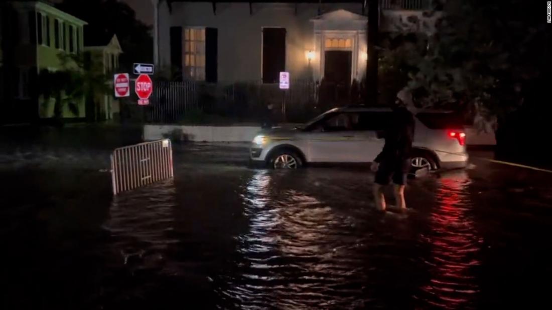
A vehicle moves through flood waters in the aftermath of Hurricane Idalia in Tarpon Springs, Florida, on Wednesday. Adrees Latif/Reuters
Hurricane Idalia roared across Florida’s Big Bend Wednesday morning as a dangerous and record-breaking Category 3 storm, leaving a deadly trail of destruction from powerful winds, pounding rain, and catastrophic storm surge.
Many organizations began preparing ahead of the storm’s arrival and are already on the ground responding to the disaster.
Learn about ways you can help support relief efforts by clicking here.
CNN Impact Your World will continue to monitor and vet ways to help and update as information comes in.
7 min ago
Warmer ocean temperatures may have increased Idalia’s destructive potential up to 50%, scientist says
From CNN's Rachel Ramirez
Before making landfall as a Category 3 storm, Hurricane Idalia went through a remarkable period of rapid intensification Tuesday night into Wednesday morning. Its maximum winds increased by 55 mph over the course of just 24 hours.
With a vast pool of warm ocean water to draw from, the storm converted that heat into wind power. Strong winds are one of the more dangerous aspects of hurricanes, in addition to storm surge and heavy rainfall.
In a post on Wednesday, meteorologist and hurricane expert Jeff Masters at Yale Climate Connections drew the line between the extra warmth, higher wind speeds and how much damage the storm could inflict. Recent research has suggested that for every 1 degree Celsius that ocean temperatures rise, hurricane wind speeds could increase by as much as 4 to 5% — which in turn can amplify the storm’s destructive potential by 40 to 50%, Masters pointed out.
In 1987, Kerry Emanuel, a professor of atmospheric science at the Massachusetts Institute of Technology, theorized that hurricane wind speed can be expected to increase by about 5% for every 1 degree Celsius that tropical ocean temperatures rise.
Tom Knutson, a senior scientist with the National Oceanic and Atmospheric Administration, told CNN that 4 to 5% is “toward the higher end of the range across studies.” Some studies, like one that Knutson authored, showed a 3.75% increase.
But that increase — however small — can dramatically increase a hurricane’s damage potential, Masters explained.
“A 4-5% increase in hurricane winds may not seem like a big deal, but damage from a hurricane increases exponentially with an increase in winds,” Masters wrote. “For example, according to NOAA, a Category 2 hurricane with 100 mph winds will do 10 times the damage of a Category 1 hurricane with 75 mph winds. This includes damage not only from winds, but also from storm surge, inland flooding, and tornadoes.”
Idalia is now a tropical storm as it moves through South Carolina, lashing the Southeast with heavy rain and sustained winds of 60 mph. Track the storm's path.
Idalia made landfall early Wednesday on Florida’s Gulf Coast as a powerful Category 3 storm. It's the strongest hurricane to make landfall in the Big Bend region, the nook between the panhandle and peninsula, in more than 125 years.
The storm is causing flooding in some areas and has left over 400,000 customers in Florida, Georgia and South Carolina without power.
Storm surges are expected to impact much of the Southeast coast through tonight as Idalia continues its path sustaining tropical storm-force winds of up to 60 mph, according to an 11 p.m. ET update from the National Weather Service (NWS).
Coastal flooding is also expected in Storm Surge Watch areas in North Carolina on Thursday, NWS noted its latest update.
Idalia is currently 15 miles northwest of Charleston, South Carolina. Here's where you can track the storm's path.
This satellite image from 11:21 a.m. ET shows Hurricane Idalia, center, over Florida and crossing into Georgia, and Hurricane Franklin, right, as it moves along off the East coast of the United States on August 30, 2023. NOAA/AP
Idalia touched down on Florida's Gulf Coast early Wednesday as a Category 3 hurricane, making it the strongest to make landfall in the Big Bend region in more than 125 years.
Idalia weakened to a tropical storm Wednesday night and continues to weaken as it treks across the Southeast, according to the National Hurricane Center.
The center of the storm is now moving through South Carolina and is 60 miles west of Charleston, the center said. In addition to the surge, heavy rain, gusty winds and the threat for tornadoes will continue into the overnight hours for eastern sections of the Carolinas.
Here's what else you should know:
Georgia: Flash flood warnings were issued across parts of Georgia as the state braced for Idalia. All flights out of Savannah/Hilton Head International Airport were canceled for the rest of Wednesday, the airport posted on social media. And government offices for the city of Savannah will remain closed Thursday due to the weather, the city announced in a news release Wednesday.
Florida: About 150 residents were rescued from flooded neighborhoods in Pasco County as Hurricane Idalia moved through Florida, according to an official. Some areas of Florida saw more than 9 inches of rain and winds up to 85 mph, according to preliminary reports. A 15-mile stretch of Interstate 10 in Madison County remains closed, although the department of transportation is working to have it re-opened tonight, Florida Gov. Ron DeSantis said Wednesday. About 4,000 to 6,000 homes were damaged in Florida's Pasco County during the storm, according to Pasco County Administrator Mike Carballa. Florida’s biggest concern following Hurricane Idalia is people who do not have power, according to Kevin Guthrie, the state's director of emergency management. Also, there have been reports of people looting in the aftermath of Hurricane Idalia in Steinhatchee, a village in hard-hit Taylor County, DeSantis said Wednesday.
The Carolinas: North Carolina Gov. Roy Cooper urged residents to stock up on supplies and stay off flooded roads when Hurricane Idalia hits the area with heavy rainfall and localized flooding. A state of emergency was declared Monday for the state and a tropical storm warning is in effect for the entire coast of the state, Cooper said. Some schools in North Carolina are closing early or canceling activities as Hurricane Idalia moves toward the state. South Carolina Gov. Henry McMaster said he doesn’t think the storm will be as bad as previous hurricanes that have hit the state.
Power outages: More than 460,000 customers are without power in Florida and Georgia on Wednesday evening, according to tracker PowerOutage.Us.
The water level in Charleston Harbor has exceeded the forecast of 8.7 feet and is now at 9.03 feet, the National Weather Service posted on X, formerly known as Twitter.
This is the fifth-highest level ever recorded and is only slightly behind values recorded in 2016 with Hurricane Matthew (9.29 feet) and 2017 with Hurricane Irma (9.92 feet). The highest level was 12.52 feet in 1989 during Hurricane Hugo.
High tide was at 8:24 p.m. ET.
The WC-130J Hercules aircraft from the 53rd Weather Reconnaissance Squadron departed Keesler Air Force Base in Biloxi, Mississippi, Tuesday at 11 p.m. ET.
The one time my soul left my body, I was on the flight deck with the pilots. It was dark for the majority of our flight. The lightning was so intense, and the hail hitting the plane was so intense.
“We’re about to go through the eye wall,” a crew member said.
I’m sitting up there with the pilots. We’re rocking and swaying, and all of a sudden, the flight controls start screaming, “Check Altitude. Check Altitude. Check Altitude. Throttle up. Throttle up.” And I’m like, ‘Oh my god, this is what happens in the movies.’
And those pilots were just cool, calm and collected, and steered us through it. It was amazing. We had one moment where we dropped really rapidly because we hit a pocket and everybody on the plane literally levitated. We were kind of airborne.
We went from Category 2 to Category 4 in a short amount of time. We were in the eye of the storm for a good eight hours. Just zigzagging in and out, penetrating different parts of the eye wall and then going back into the eye. We knew we were in the eye and that’s when everybody kind of got up. They would get a drink of water.
In the eye itself, it was super calm. There was no turbulence. As soon as we started to rock a little bit everybody ran back to their jump seats and sat down. As we’re crisscrossing in and out, you can feel every time we reentered the eye wall. You could feel the intensity of the turbulence a little bit more, then a little bit more, and a little bit more. Every time.
Everybody’s job is so vital to the mission and so crucial to the safety of that flight that they can’t stop when there’s turbulence. They have to keep doing what they need to do. It was serious. It was all business. Hours later, the aircraft approached Keesler over the glistening water and landed safely.
Idalia was the first major hurricane – Category 3 or stronger – on record to track through Florida’s Apalachee Bay, a northern inlet in the Big Bend.
Here are some of the preliminary reports of rain and wind conditions from the National Weather Service:
Rain:
Clearwater Beach in Pinellas County: 9.4 inches
Chiefland in Levy County: 9.18 inches
Land O Lakes in Pasco County: 5.54 inches
Desoto Lakes in Manatee County: 4.45 inches
Tampa in Hillsborough County: 3.73 inches
Wind:
Perry-Foley Airport in Taylor County: 85 mph
Keaton Beach, the location of landfall, in Taylor County: 77 mph
Sarasota in Manatee County: 70 mph
Cedar Key in Levy County: 66 mph
Clearwater Beach in Pinellas County: 65 mph
Tampa International Airport in Hillsborough County: 61 mph
St. Petersburg in Pinellas County: 58 mph
A vehicle moves through flood waters in the aftermath of Hurricane Idalia in Tarpon Springs, Florida, on Wednesday. Adrees Latif/Reuters
Hurricane Idalia roared across Florida’s Big Bend Wednesday morning as a dangerous and record-breaking Category 3 storm, leaving a deadly trail of destruction from powerful winds, pounding rain, and catastrophic storm surge.
Many organizations began preparing ahead of the storm’s arrival and are already on the ground responding to the disaster.
Learn about ways you can help support relief efforts by clicking here.
CNN Impact Your World will continue to monitor and vet ways to help and update as information comes in.
Before making landfall as a Category 3 storm, Hurricane Idalia went through a remarkable period of rapid intensification Tuesday night into Wednesday morning. Its maximum winds increased by 55 mph over the course of just 24 hours.
With a vast pool of warm ocean water to draw from, the storm converted that heat into wind power. Strong winds are one of the more dangerous aspects of hurricanes, in addition to storm surge and heavy rainfall.
In a post on Wednesday, meteorologist and hurricane expert Jeff Masters at Yale Climate Connections drew the line between the extra warmth, higher wind speeds and how much damage the storm could inflict. Recent research has suggested that for every 1 degree Celsius that ocean temperatures rise, hurricane wind speeds could increase by as much as 4 to 5% — which in turn can amplify the storm’s destructive potential by 40 to 50%, Masters pointed out.
In 1987, Kerry Emanuel, a professor of atmospheric science at the Massachusetts Institute of Technology, theorized that hurricane wind speed can be expected to increase by about 5% for every 1 degree Celsius that tropical ocean temperatures rise.
Tom Knutson, a senior scientist with the National Oceanic and Atmospheric Administration, told CNN that 4 to 5% is “toward the higher end of the range across studies.” Some studies, like one that Knutson authored, showed a 3.75% increase.
But that increase — however small — can dramatically increase a hurricane’s damage potential, Masters explained.
“A 4-5% increase in hurricane winds may not seem like a big deal, but damage from a hurricane increases exponentially with an increase in winds,” Masters wrote. “For example, according to NOAA, a Category 2 hurricane with 100 mph winds will do 10 times the damage of a Category 1 hurricane with 75 mph winds. This includes damage not only from winds, but also from storm surge, inland flooding, and tornadoes.”