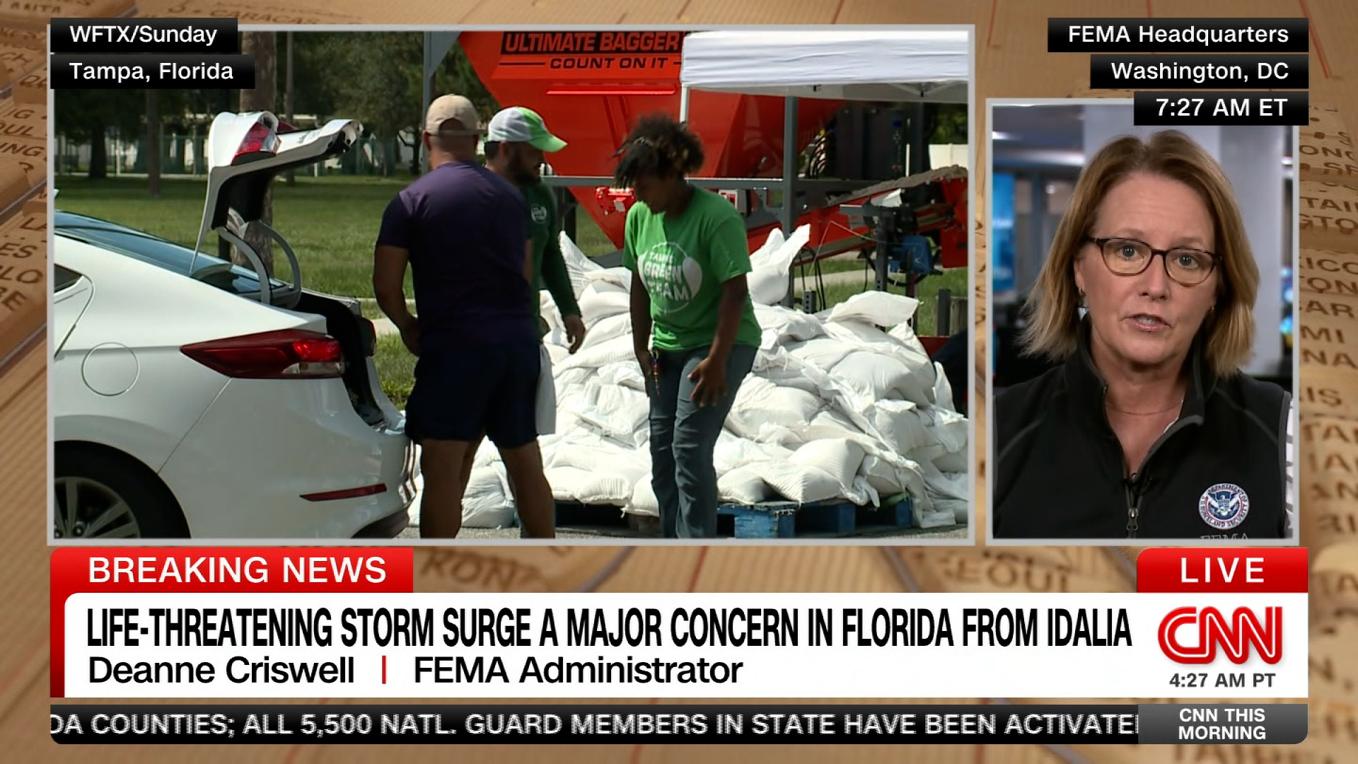
Follow any evacuation orders and be aware of storm surge, FEMA chief advises Floridians ahead of Idalia
Federal Emergency Management Agency Administrator Deanne Criswell warned Florida residents in the path of Hurricane Idalia to heed evacuation orders and be aware of storm surge.
"The most important thing right now for all Floridians is to make sure that they know where they're at and what their risk is going to be as it relates to this storm. It is a Category 1 now. We expect it to intensify. We expect it to make landfall as possibly a Category 3. But it's also the storm surge that's so significant. So the first thing that I just want to tell everybody in Florida is listen to your local officials. If they ask you to evacuate, please do so," she told CNN.
"The number-one killer in all of these storms is water," she added.
If you are asked to evacuate, be sure to take all your important documents with you, Criswell said.
In Florida, FEMA search and rescue teams are “on standby” and Army Corps of Engineers is “ready to support power generation” efforts. There are also teams ready to go door-to-door to assess damage after the storm passes, according to Criswell.
FEMA is also in contact with officials in Georgia, North Carolina, and South Carolina, which, Criswell said, “will also feel some impacts.”
CNN's Betsy Klein contributed reporting to this post.
18 min ago
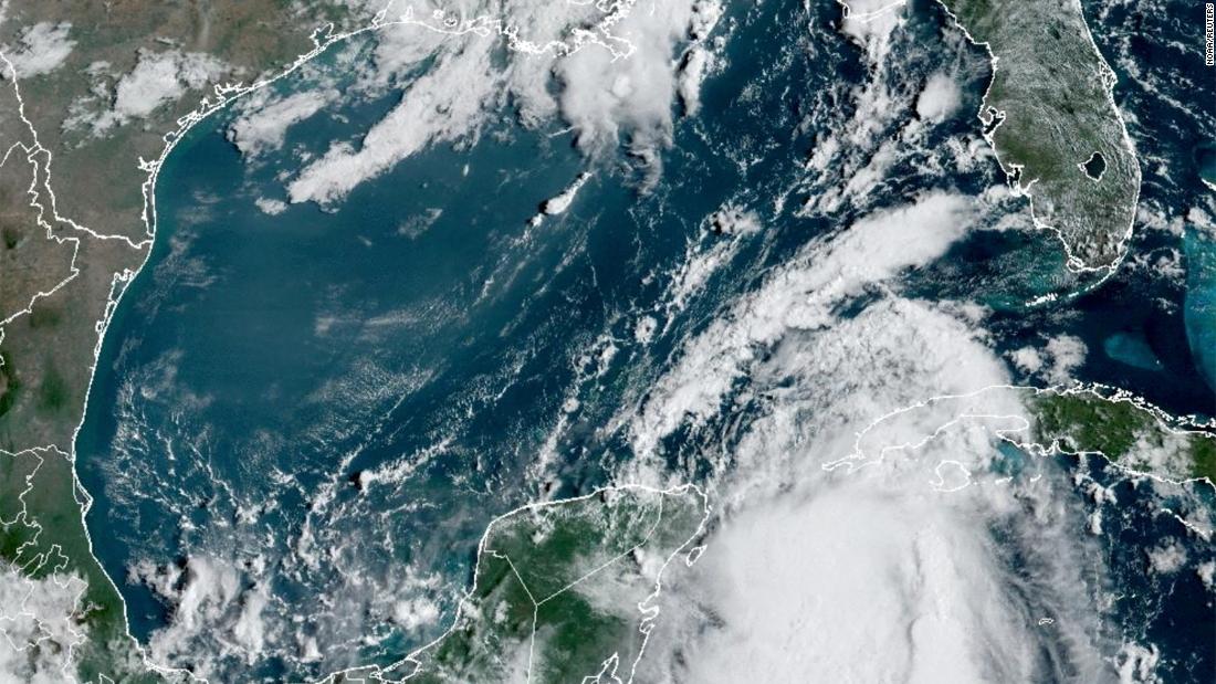
Idalia is expected to rapidly intensify — something that's becoming more common thanks to climate crisis
From CNN’s Rachel Ramirez
Idalia is expected to rapidly intensify as it tracks through the Gulf of Mexico, tapping into some of the warmest waters on the planet ahead of making landfall in Florida this week.
If it does so, it would join a growing list of devastating storms like Hurricane Ian — which leveled coastal Florida and left more than 100 dead — to rapidly intensify before landfall in recent years.
Idalia posed a “notable risk” of this so-called rapid intensification phenomenon, the National Hurricane Center warned Monday, as it travels through the Gulf of Mexico. Water temperatures around southern Florida climbed to 100 degrees Fahrenheit in some areas this summer, and temperatures in the Gulf overall have been record-warm, with more than enough heat to support rapid strengthening.
Ocean temperatures are around “1 to 2 degrees Celsius (roughly 2 to 3.5 degrees Fahrenheit) above normal for this time of year, which is a lot when you consider this is already a super-hot time of year,” Brian McNoldy, an atmospheric scientist at the University of Miami, told CNN. “With that in mind, and with those extra warm waters ahead of it, it does make rapid intensification more likely to happen.”
The impact of the climate crisis:Rapid intensification is precisely what it sounds like — when a storm’s winds strengthen rapidly over a short amount of time. Scientists have defined it as a wind speed increase of at least 35 mph in 24 hours or less.
Concerningly, it has been happening more and more as storms are approaching landfall, making them harder to prepare for and more dangerous to the people who stayed behind expecting a weaker storm.
It’s just one of the ways experts say the climate crisis is making hurricanes more dangerous, as warmer waters allow for storms to strengthen more quickly. More than 90% of warming around the globe over the past 50 years has taken place in the oceans, according to the National Oceanic and Atmospheric Administration.
32 min ago
Preparations are underway as Idalia strengthens into a hurricane: Here's the latest
From CNN's Nouran Salahieh, Joe Sutton and Rachel Ramirez
Residents place a wooden board to protect a house in St. Petersburg, Florida, on Monday. Juan Manuel Barrero Bueno/Bloomberg via Getty Images
Idalia has strengthen into a Category 1 hurricane and is expected to hit Florida this week as a powerful Category 3 storm.
As the storm makes its way to the panhandle, preparations could be seen across the state. Here’s the latest:
Airports close: Tampa International Airport will suspend all commercial operations beginning Tuesday and stay closed until it can assess any damages later in the week, airport officials announced. The St. Pete-Clearwater International Airport Terminal building will close Tuesday afternoon.
Evacuations in at least 10 counties: Hillsborough, Franklin, Taylor, Levy, Citrus, Manatee, Pasco, Hernando, Pinellas and Sarasota counties have all called for residents to evacuate certain at-risk areas.
Schools close: 32 County School Districts have issued closures, as did multiple colleges and universities, including Florida State University, the University of Florida and Florida A&M University.
Emergencies declared: Florida Gov. Ron DeSantis expanded an emergency declaration to 46 of 67 Florida counties on Monday morning. Several local jurisdictions have also declared emergencies.
The Florida National Guard activated: More than 5,000 National Guard members were activated to help respond to the storm.
US Navy ships begin leaving: Navy ships have begun leaving Florida ahead of Tropical Storm Idalia’s landfall, the Navy said Monday.
Power outages expected: DeSantis told residents to prepare to be without power. “If you are in the path of the storm, you should expect power outages so please prepare for that,” the governor told residents Sunday.
Hospital system suspending services: Patients will be transferred from at least three hospitals: HCA Florida Pasadena Hospital, HCA Florida Trinity West Hospital and HCA Florida West Tampa Hospital.
“We want everyone to take this storm seriously,” Tampa’s Fire Rescue Chief Barbara Tripp said during a news conference.
The fire chief also asked citizens to clear debris from property ahead of the storm’s arrival and look out for neighbors who may need help.
“Once the wind reaches a certain miles per hour, Tampa Fire Rescue will not be able to respond,” Tripp warned.
29 min ago
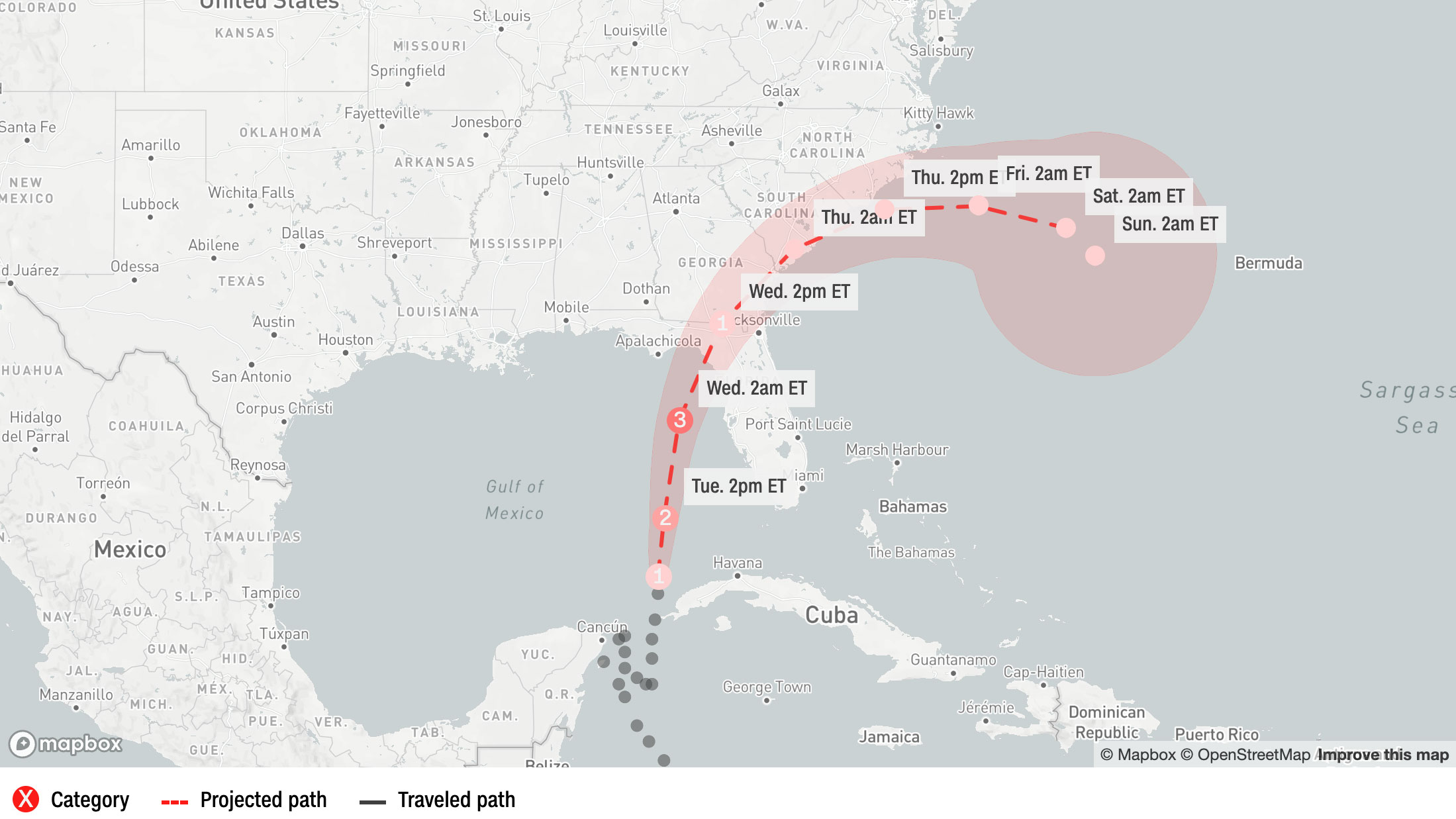
Idalia has strengthened into a hurricane as it heads toward Florida
From CNN's Nouran Salahieh, Joe Sutton and Rachel Ramirez
Mapbox/CNN
Idalia has strengthened into a hurricane with maximum sustained winds of 75 mph and stronger gusts and is expected to intensify considerably into a powerful Category 3 hurricane before making landfall in Florida on Wednesday, according to the National Hurricane Center.
The storm could deliver a devastating blow to portions of Florida’s Gulf Coast with life-threatening storm surge and damaging winds. It is expected to make landfall well north of Tampa, in Florida’s Big Bend region, but a small shift in the track could put the vulnerable population center more at risk.
Before it makes landfall, Idalia could produce a few tornadoes along the west central Florida coast Tuesday and northward into the Florida Big Bend by Tuesday night. Heavy rain could produce flash flooding across portions of the west coast of Florida, the Florida Panhandle, and southern Georgia Tuesday into Wednesday, spreading into portions of the eastern Carolinas Wednesday into Thursday.
The storm was churning roughly 370 miles southwest of Tampa early Tuesday, the hurricane center said in a 5 a.m. update.
“This is going to be a major hurricane,” Gov. Ron DeSantis said at a Monday news conference.
The storm is expected to dump 4 to 8 inches of rain from Tuesday into Thursday across parts of the west coast of Florida, the Florida Panhandle, southeast Georgia and the eastern Carolinas – where streets could flood.
Idalia has strengthened into a hurricane with maximum sustained winds of 75 mph and is expected to intensify considerably into a powerful Category 3 hurricane before making landfall in Florida on Wednesday.
Hurricane Idalia is located 85 miles north of the western tip of Cuba, moving north at 14 mph. CNN is tracking the storm's path.
Officials warned there could be storm surges of 10-12 feet along parts of the Gulf Coast. "This is going to be a major hurricane,” Gov. Ron DeSantis said, urging people to listen to evacuation orders.
Federal Emergency Management Agency Administrator Deanne Criswell warned Florida residents in the path of Hurricane Idalia to heed evacuation orders and be aware of storm surge.
"The most important thing right now for all Floridians is to make sure that they know where they're at and what their risk is going to be as it relates to this storm. It is a Category 1 now. We expect it to intensify. We expect it to make landfall as possibly a Category 3. But it's also the storm surge that's so significant. So the first thing that I just want to tell everybody in Florida is listen to your local officials. If they ask you to evacuate, please do so," she told CNN.
"The number-one killer in all of these storms is water," she added.
If you are asked to evacuate, be sure to take all your important documents with you, Criswell said.
In Florida, FEMA search and rescue teams are “on standby” and Army Corps of Engineers is “ready to support power generation” efforts. There are also teams ready to go door-to-door to assess damage after the storm passes, according to Criswell.
FEMA is also in contact with officials in Georgia, North Carolina, and South Carolina, which, Criswell said, “will also feel some impacts.”
CNN's Betsy Klein contributed reporting to this post.
Idalia is expected to rapidly intensify as it tracks through the Gulf of Mexico, tapping into some of the warmest waters on the planet ahead of making landfall in Florida this week.
If it does so, it would join a growing list of devastating storms like Hurricane Ian — which leveled coastal Florida and left more than 100 dead — to rapidly intensify before landfall in recent years.
Idalia posed a “notable risk” of this so-called rapid intensification phenomenon, the National Hurricane Center warned Monday, as it travels through the Gulf of Mexico. Water temperatures around southern Florida climbed to 100 degrees Fahrenheit in some areas this summer, and temperatures in the Gulf overall have been record-warm, with more than enough heat to support rapid strengthening.
Ocean temperatures are around “1 to 2 degrees Celsius (roughly 2 to 3.5 degrees Fahrenheit) above normal for this time of year, which is a lot when you consider this is already a super-hot time of year,” Brian McNoldy, an atmospheric scientist at the University of Miami, told CNN. “With that in mind, and with those extra warm waters ahead of it, it does make rapid intensification more likely to happen.”
The impact of the climate crisis:Rapid intensification is precisely what it sounds like — when a storm’s winds strengthen rapidly over a short amount of time. Scientists have defined it as a wind speed increase of at least 35 mph in 24 hours or less.
Concerningly, it has been happening more and more as storms are approaching landfall, making them harder to prepare for and more dangerous to the people who stayed behind expecting a weaker storm.
It’s just one of the ways experts say the climate crisis is making hurricanes more dangerous, as warmer waters allow for storms to strengthen more quickly. More than 90% of warming around the globe over the past 50 years has taken place in the oceans, according to the National Oceanic and Atmospheric Administration.
Residents place a wooden board to protect a house in St. Petersburg, Florida, on Monday. Juan Manuel Barrero Bueno/Bloomberg via Getty Images
Idalia has strengthen into a Category 1 hurricane and is expected to hit Florida this week as a powerful Category 3 storm.
As the storm makes its way to the panhandle, preparations could be seen across the state. Here’s the latest:
Airports close: Tampa International Airport will suspend all commercial operations beginning Tuesday and stay closed until it can assess any damages later in the week, airport officials announced. The St. Pete-Clearwater International Airport Terminal building will close Tuesday afternoon.
Evacuations in at least 10 counties: Hillsborough, Franklin, Taylor, Levy, Citrus, Manatee, Pasco, Hernando, Pinellas and Sarasota counties have all called for residents to evacuate certain at-risk areas.
Schools close: 32 County School Districts have issued closures, as did multiple colleges and universities, including Florida State University, the University of Florida and Florida A&M University.
Emergencies declared: Florida Gov. Ron DeSantis expanded an emergency declaration to 46 of 67 Florida counties on Monday morning. Several local jurisdictions have also declared emergencies.
The Florida National Guard activated: More than 5,000 National Guard members were activated to help respond to the storm.
US Navy ships begin leaving: Navy ships have begun leaving Florida ahead of Tropical Storm Idalia’s landfall, the Navy said Monday.
Power outages expected: DeSantis told residents to prepare to be without power. “If you are in the path of the storm, you should expect power outages so please prepare for that,” the governor told residents Sunday.
Hospital system suspending services: Patients will be transferred from at least three hospitals: HCA Florida Pasadena Hospital, HCA Florida Trinity West Hospital and HCA Florida West Tampa Hospital.
“We want everyone to take this storm seriously,” Tampa’s Fire Rescue Chief Barbara Tripp said during a news conference.
The fire chief also asked citizens to clear debris from property ahead of the storm’s arrival and look out for neighbors who may need help.
“Once the wind reaches a certain miles per hour, Tampa Fire Rescue will not be able to respond,” Tripp warned.
Mapbox/CNN
Idalia has strengthened into a hurricane with maximum sustained winds of 75 mph and stronger gusts and is expected to intensify considerably into a powerful Category 3 hurricane before making landfall in Florida on Wednesday, according to the National Hurricane Center.
The storm could deliver a devastating blow to portions of Florida’s Gulf Coast with life-threatening storm surge and damaging winds. It is expected to make landfall well north of Tampa, in Florida’s Big Bend region, but a small shift in the track could put the vulnerable population center more at risk.
Before it makes landfall, Idalia could produce a few tornadoes along the west central Florida coast Tuesday and northward into the Florida Big Bend by Tuesday night. Heavy rain could produce flash flooding across portions of the west coast of Florida, the Florida Panhandle, and southern Georgia Tuesday into Wednesday, spreading into portions of the eastern Carolinas Wednesday into Thursday.
The storm was churning roughly 370 miles southwest of Tampa early Tuesday, the hurricane center said in a 5 a.m. update.
“This is going to be a major hurricane,” Gov. Ron DeSantis said at a Monday news conference.
The storm is expected to dump 4 to 8 inches of rain from Tuesday into Thursday across parts of the west coast of Florida, the Florida Panhandle, southeast Georgia and the eastern Carolinas – where streets could flood.