


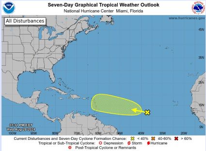
It is very late August, we are at the peak of Hurricane Season, and the Atlantic is devoid of any tropical activity. A quick look at NOAA’s Seven-Day Tropical Weather Outlook map shows not even a disturbance between Texas and Africa, and less than a 40% chance that something will develop by early September.
As a quick reminder, the corrupted “scientific” doomsayers predicted this to be an unprecedented hurricane season, with near-constant storms reaching a record total, and a huge percentage of them catastrophically destructive. Something that was repeated in doom story after doom story was there being “record warm Atlantic Ocean waters,” due to your sinful, carbon-addicted lifestyle, which is causing the oceans to boil.
To repeat, it was a scientific fact according to the most celebrated “climate experts” that we were in grave peril from hurricanes in 2024 due to “record warm Atlantic Ocean waters.” I’m repeating this because as it turned out, the Atlantic Ocean water temperatures have plunged this summer, in spite of the brilliance of the climate scientists who claim the ability to precisely predict air and ocean temperatures out decades in the future.
First off, here are a few headlines from the past few months as the hyperbole built for this horror-movie hurricane season, as well as a few quotes from these stories about the impending hurricane apocalypse.
Of note, a La Niña is a situation in which there is below-normal equatorial water temperatures in the Pacific Ocean.
The start of the 2024 Atlantic hurricane season is just over a week away, and federal forecasters Thursday predicted an "extraordinary" season with as many as 25 named storms possible. This is the most storms the National Oceanic and Atmospheric Administration has ever predicted in a preseason outlook.
Michael Mann, the famed “climate expert” of hockey-stick fame, went even further, predicting a whopping 33 named tropical storms this year.
{Mann’s team] forecast an unprecedented 33 named tropical cyclones, potentially ranging between 27 and 39. “We’ve seen many hyperactive seasons over the past decade, and in just about all cases, like our prediction for this year, the activity is substantially driven by ever-warmer conditions in the tropical Atlantic tied to large-scale warming,” says Mann.
When a “rare” July hurricane* entered the Caribbean and then “slammed” into Texas as a weak Category 1 hurricane, the media somehow went into an even greater degree of hysteria.
(*There have been 26 prior July hurricanes that have hit the US mainland since 1850, but this one, number 27, somehow was proof positive that the angry climate God was now seeking retribution against us carbon sinners.)
"Extremely warm sea surface temperatures provide a much more conducive dynamic and thermodynamic environment for hurricane formation and intensification," the [Colorado State University Department of Atmospheric Science] said in an online post. The department also described Hurricane Beryl as "a likely harbinger of a hyperactive season."
Hurricane season starts on June 1 every year, but one hurricane in July caused the climate community to lose its mind and start quoting from the Book of Climate Revelations.
“'An early and violent start': NOAA issues dire hurricane season forecast” [USA Today – 8/08/2024]
But something happened, or maybe I should say didn’t happen. The seas calmed, and as we hit the peak of hurricane season in late August, the tropical Atlantic has completely shut down the production of tropical storms. The climate prophets were wrong again.
So what happened? The answer is that the Atlantic Ocean cooled off this summer. Literally.
“'The tropics are broken:' So where are all the Atlantic hurricanes?” [USA Today – 8/26/2024]
The 2024 hurricane season is not going as predicted – yet.
"It is quiet out there," Colorado State University meteorologist Phil Klotzbach told USA TODAY on Monday. "I certainly wasn't expecting this when we put out our most recent seasonal forecast.
This was supposed to be a record year for hurricanes. Well, it is in a way – it’s record quiet.
Klotzbach said that if we look at named storms (tropical storms, subtropical storms and hurricanes), the last time that we went from Aug. 21 to Sept. 2 with no named storm activity in the Atlantic was 1997.
The Atlantic is record quiet because of cold water that prevents the development of tropical storms.
"The Atlantic tropics are broken – for now," meteorologist Ryan Maue posted on X Sunday, adding that developing storms near Africa are encountering at least one problem: "Ocean temperatures at this latitude are way too cool to sustain a rain shower."
The Washington Post just published an unintentionally hilarious piece about this year’s failed hurricane prognosis. It reads like the climate version of a coach’s halftime speech as he tries to rally the team to believe that even though they’re losing 24-0, they are absolutely positioned for the victory he promised.
Key ingredients are in place for an active final few months of hurricane season, which officially ends Nov. 30. La Niña, known to encourage busy Atlantic hurricane seasons, is forecast to arrive before then, and there are signs it is developing quickly.
“We are due for at least one or two more bursts of activity, easily,” [NOAA hurricane forecaster Matthew] Rosencrans said. “This lull is not that the season is done.”
So how do the Atlantic waters cool off during the worst heat of summer? It is a phenomenon that is understood by actual scientists, and while it does not portend “global cooling,” it does refute the nonsense of the climate apocalysts.
“Party Over for Alarmists as Sea Temperatures Plunge Around the World” [Daily Sceptic – 8/28/2024]
It is not unusual for waters in these parts of the Atlantic to cool in the summer months as seasonal southern winds drag surface waters away from the equator and expose deeper colder water. The process is called ‘upwelling’, but this year it coincided with a weakening of the trade winds which should have led to warmer anomalies.
This has the propagandists at NOAA flummoxed, because they wrote a program with a pre-determined outcome that concludes with “record warm waters,” but they didn’t take into account upwelling.
In fact, scientists have little idea how a great deal of weather suddenly changes and how the sea and atmosphere warms and cools. Over 100 super-computer models are simply not up to the job of explaining natural variation in a chaotic, non-linear atmosphere. The fact that some scientists are perplexed when temperatures go down, but full of fear-mongering explanations when they go up, says it all.
One more related item… Even though the entire Atlantic basin is bereft of storms right now, up until the introduction of satellites into meteorology a few decades ago, there was no way to even know if there were storms out in the open ocean with sustained winds that warranted being “named.”
Dr. Neil Frank, an actual scientist who is not profiting from the climate grift, is also the former head of the National Hurricane Center. In the video further below from a Heartland Institute climate conference, he uses these two maps to show the named storms that occurred in two very busy hurricane seasons – 1933 and 2005. The black line represents the eastern extent of reconnaissance aircraft prior to the satellite era.
In 1933 there were 21 named storms, none of which were in the Eastern Atlantic.
In 2005, there were 7 storms that formed in the Eastern Atlantic and never moved into the Western Atlantic. They would have never been identified as named storms in prior eras. Naturally, when you are finding storms where you didn’t formerly look, you’re going to find more of them, hence we have more named storms in the modern era.
Have a blessed Labor Day weekend. The good news is that whatever beach you might be heading to, you won’t have to worry about hurricanes.
[buck.throckmorton at protonmail dot com]